Nearby Hiking TrailsAs a service to its guests, Enota
Mountain Retreat wants to make the following information available. This trail information is provided by the: Brasstown Ranger District - Chatahoochee National ForestPO Box 8 - Blairsville, GA 30514 The 157,000-acre
Brasstown Ranger District is pat of the Chattahoochee National Forest. This District guide will help you enjoy
opportunities that range from day hikes to extended backpacking. These trails pass through a variety of forest types and
management practices. The trail difficulty levels range from easy to difficult. Most
of the trailheads provide parking areas. Contact the District Office for updated trail information and directions. You are responsible for leaving the forest clean and free of litter. Leave
No Trace of your visit! Leave No Trace TipsÏ Plan ahead and
prepare Ï Travel and
camp or durable surfaces Ï Dispose of
waste properly Ï Leave what you
find Ï Minimize
campfire impacts Ï Respect
wildlife Ï Be considerate
of other visitors Day Hikes
Brasstown Bald Summit Trail
Length: 0.6 miles Difficulty: Moderate Use: Heavy
This trail begins in the Brasstown Bald parking area and climbs to the Visitor Center atop Brasstown Bald, the highest
mountain in Georgia (4,784 ft). Arkaquah Trail
Length: 5.5 miles Difficulty: Moderate Use: Moderate
This blue-blazed trail is accessed from the parking area for the Brasstown Bald Visitor Center or from the Trackrock
Archeological Site on Trackrock Road. The trail descends along a ridge and the lower mile is steep. Most of this trail is located within the Brasstown Wilderness. Blazes are infrequent in Wilderness. Jacks Knob Trail
Length: 4.5 miles Difficulty: Moderate Use: Moderate
This blue-blazed trail begins with a short climb from the Brasstown Bald parking lot and descends 1,500 feet through a
series of switchbacks that cover 2.3 miles. It crosses GA highway 180 in Jacks Gap and then climbs 2.2 miles to the
Appalachian Trail at Chattahoochee Gap. Approximately 0.2 miles south of Jacks Gap, the trail enters Mark Trail
Wilderness. Blazes are infrequent in Wilderness. Bear Hair Trail
Length: 3.6 miles Difficulty: Moderate Use: Heavy
This orange-blazed trail begins in Vogel State Park north of Neels Gap on US highway 129.
The trail shares a portion of its route with the Coosa Backcountry Trail. A spur trails leads to an overlook
above Lake Trahlyta. A portion of this trail is within the Blood Mountain Wilderness. Blazes are infrequent in
Wilderness. Byron Herbert Reece Trail
Length: 0.7 miles Difficulty: Moderate Use: Heavy
This blue-blazed trail begins in the Byron Herbert Reece Memorial parking area on the north of Neels Gap on US highway 129. The trail climbs to the Appalachian Trail just south of Flat Rock Gap near one end of the Freeman Trail. This trail is within the Blood Mountain Wilderness. Blazes are infrequent in Wilderness. Freeman Trail
Length: 1.8 miles Difficulty: Moderate Use: Moderate
This blue-blazed trail winds around the south slopes of Blood Mountain, connecting with the Appalachian Trail at Flat Rock
Gap and Bird Gap. This trail is within the Blood Mountain Wilderness and can be accessed via the Appalachian Trail at
Neels Gap or at the Byron Herbert Reece Memorial, both located on US highway 129. This trail is within the Blood
Mountain Wilderness. Blazes are infrequent in Wilderness. Cooper Creek Trail
Length: 0.4 miles Difficulty: Easy Use:
Light
This blue-blazed trail is a connector trail between the Millshoals and Yellow Mountain Trails. This trail can be reached by hiking 0.6 miles from the Millshoals trailhead or 1.0 mile from the Yellow Mountain Trailhead,
both on FS # 236. Various loop hikes can be made by using combinations of Cooper Creek, Shope Gap, Yellow Mountain, and
Millshoals Trails. Shope Gap Trail
Length: 0.6 miles Difficulty: Moderate Use: Light
This green-blazed trail is accessed via the Yellow Mountain Trail 1.3 miles from the Trailhead on FS #236. The trail continues north and intersects with FS #39 at Shope Gap. Yellow Mountain Trail
Length: 2.7 miles Difficulty: Moderate to Strenuous Use: Light
This yellow-blazed trail begins 300 yards from the Cooper Creek Recreation Area on FS #236.
The trail meanders through a forest of hemlock, white pine and hardwoods. The trail crosses Bryant Creek, ending
at Addie Gap of FS #33A. Millshoals Trail
Length: 2.4 miles Difficulty: Moderate
Use: Light
This yellow-blazed trail begins 300 yards from the Cooper Creek Recreation Area on FS #236.
The trail meanders through a forest of hemlock, white pine and hardwoods. The trail crosses Bryant Creek, ending
at Addie Gap of FS #33A. DeSoto Falls Trail
Length: 1.0 miles Difficulty: Easy to Moderate Use:
Heavy
The trail begins at the bridge in the lower loop of the DeSoto Falls Recreation Area campground. The Lower Falls are 1/4 mile downstream and the Upper Falls are 3/4 mile upstream from this point. The trail follows Frogtown Creek through rhododendron, mountain laurel and hemlock. Please
do not climb around the waterfalls. Dockery Lake Trail
Length: 3.5 miles Difficulty: Easy to Strenuous Use:
Moderate
This blue-blazed trail begins in the Dockery Lake Recreation Area off GA Highway 60 in Woody Gap. The trail crosses several creeks, and then climbs steeply up to the Appalachian Trail in Miller Gap. A
portion of this trail is within the Blood Mountain Wilderness. Blazes are infrequent in Wilderness. Helton Creek Falls Trail
Length: 0.2 miles Difficulty: Easy Use: Heavy
This trail begins 2.3 miles east of US highway 129 on Helton Creek Road near Vogel State Park. This short trail descends to the first waterfall then climbs beside the creek to the second and larger waterfall. Please do not climb around the waterfalls. High Shoals Trail
Length: 1.2 miles Difficulty: Moderate Use:
Heavy
This blue-blazed trail begins 1.5 miles east of GA 17/75 on FS #283 north of Unicoi Gap.
The trail descends through a series of long switchbacks to High Shoals Creek, then follows the creek to viewing platforms at two waterfalls. Please do not climb around the waterfalls. Rocky Mountain Trail
Length: 1 mile Difficulty: Moderate Use:
Light to Moderate
This blue-blazed trail climbs gradually from FS #283 to the Appalachian Trail on the side of Rocky Mountain. Combining the Appalachian and Rocky Mountain Trails and FS #283 from the Appalachian Trail crossing at Indian Grave Gap can
make a loop hike. Lake Chatuge Trail
Length: 1.2 miles Difficulty: Easy Use:
Moderate
This loop trail follows the lakeshore at Lake Chatuge Recreation Area on GA 288 near Hiawassee. Lake Winfield Scott Trail
Length: 0.4 miles Difficulty: Easy Use:
Heavy
This trail follows the lakeshore at Lake Winfield Scott Recreation Area on GA 180 west of Vogel State Park. Jarrard Gap Trail
Length: 1 mile Difficulty: Moderate Use:
Moderate
This blue-blazed trail begins in the Lake Winfield Scott Recreation and climbs gradually to the Appalachian Trail at Jarrard
Gap. A loop hike can be made using Jarrard Gap, Appalachian and Slaughter Creek Trails. Slaughter Creek Trail
Length: 2.7 miles Difficulty: Moderate Use:
Moderate to Heavy
This blue-blazed trail begins in the Lake Winfield Scott Recreation and climbs gradually to the Appalachian Trail south of
Blood Mountain. A portion of this trail is within the Blood Mountain Wilderness. Blazes are infrequent in Wilderness. Sosebee Cove Trail
Length: 0.25 miles Difficulty: Moderate Use:
Easy
This trail is located on GA 180 west of Vogel State Park. The loop trail
circles through a second-growth cove hardwood forest with many large trees and an outstanding variety of wildflowers. This
area is a memorial to Arthur Woody, who served as the first Forest Service Ranger in Georgia. Miller Trek
Length: 5.5 miles Difficulty: Moderate Use:
Moderate
This orange-blazed loop trail begins in the Brasstown Valley Resort on US 76 near Young Harris. The trail winds through upland hardwoods and coves. Miller Trek honors US Senator Zell Miller, a Young
Harris native. Long Trails The Appalachian Trail in Georgia
The Appalachian Trail is one of the longest maintained trails in the world. Beginning
atop Springer Mountain in Georgia and ending 2,100 miles on Mount Katahdin in Maine, the AT passes through 14 states, and draws hikers from all over the world. In Georgia, the US Forest Service and the Georgia Appalachian Trail Club have worked together to maintain the 79 miles of
trail and protect its corridor lands. In 1968, Congress authorized the Appalachian Trail as the first National Scenic
Trail. Appalachian
National Scenic Trail Springer
Mountain to Bly Gap (GA-NC Border) Length: 67 miles Difficulty: Easy to Strenuous Use: Heavy
Passing through the Brasstown, Tallulah,
Chattooga, and Toccoa Ranger Districts, the Appalachian Trail is marked with
2x6 white blazes. This trail crosses over some of the highest mountains in the state and offers outstanding views
of the southern Appalachians. Several road crossings allow the Appalachian Trail in Georgia to be hiked in sections. Duncan Ridge
National Recreation Trail Near Three
Forks to Slaughter Gap Length: 31miles
Difficulty: Moderate to Strenuous Use: Light to Moderate
The Duncan Ridge Trails is a ridge top that connects with the Appalachian Trail near Three Forks on the Toccoa District near
Blood Mountain on the Brasstown District. The start of the trail is a little more than 1.0 mile from FS #58 near Three
Forks on the Appalachian Trail and is blue-blazed from here to Mulky Gap (the trail within the Toccoa District). After
crossing FS #4 in Mulky Gap, the trail is within the Brasstown District Coosa
Backcountry Trail Length: 11.8 miles Difficulty: Moderate to Strenuous; Use: Moderate
The main trailhead for this yellow-blazed trail is located within Vogel State Park on GA 180.
The park requires a free permit for hikers that begin there. This trail passes through several forest
environments, and has significant elevation changes along its route. A portion of this trail is within the Blood
Mountain Wilderness. Blazes are infrequent in Wilderness. Nearby WaterfallsWe hope you take advantage of natures beauty while youre at Enota. This
information is offered as a guide only. Other waterfalls, hiking trails and scenic areas await your discovery. The north Georgia Mountains offer a wide array of beautiful waterfalls. Each
offers its own characteristics, from bold and beautiful to subtle and delicate. Only a few waterfalls are visible from the road or parking areas. Most
waterfalls are easily reached and require varying lengths of walks or hikes. Anna Ruby Falls (Chattooga Ranger District) The Anna Ruby Falls trail (0.4 miles) is paved but relatively steep. Benches are
located along the trail for those who want to sit and rest or just enjoy the scenic beauty. At the base of the falls, an
observation deck offers a beautiful view of the twin falls. Directions: From
Enota, take a right onto Hwy 180, turning right onto Hwy 75 toward Helen. Just before Helen, turn left onto Hwy 356 for
1.5 miles; go left on the entrance road to the falls. This is a fee area with bathrooms, visitors center, nature
trail and gift shop. Dukes Creek Falls (Chattooga Ranger District) The Dukes Creek Falls Trail (0.8 miles) winds its way into Dukes Creek Gorge where it dead-ends across from the 300-foot falls. The area enjoys scenic beauty and offers excellent gold panning opportunities. Directions: From
Enota, take a right onto Hwy 180, turning right onto Hwy 75 toward Helen. Just before Helen, turn right only Hwy 356 (75
Alternate) for 2.3 miles to the Russell-Brasstown Scenic Byway. Turn right and go 2.0 miles to the Dukes Creek Falls
Recreation Area. Dukes Creek Falls (Chattooga Ranger District) The Dukes Creek Falls Trail (0.8 miles) winds its way into Dukes Creek Gorge where it dead-ends across from the
300-foot falls. The area enjoys scenic beauty and offers excellent gold panning opportunities Directions: From
Enota, take a right onto Hwy 180, turning right onto Hwy 75 toward Helen. Just before Helen, turn right only Hwy 356 (75
Alternate) for 2.3 miles to the Russell-Brasstown Scenic Byway. Turn right and go 2.0 miles to the Dukes Creek Falls
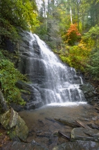
Recreation Area. High Shoals Falls (Brasstown Ranger District) Five waterfalls offer a progression with an estimated total vertical drop of 300 feet. High Shoals Trail (1.2 miles) follows along High Shoals Creek to observation decks beside two of the five streams cascading
in the High Shoals Scenic Area. Remember to stay on the trails and observation deck. Directions: From Enota, take a right onto Hwy 180, turning right onto Hwy 75 toward Helen. Approximately
.75 miles; turn left onto FS Road 283 at the sign. Go 1.5 miles on this road to the High Shoals Scenic Area. Horse Trough Falls (Chattooga Ranger District) The Horse Trough Falls Trail (0.4 miles) leads to the beautiful Horse Trough Falls. Its an excellent trail for novice hikers. Directions: From
Enota, take a right onto Hwy 180, turning right onto Hwy 75 toward Helen to Unicoi Gap. Turn right onto FS Road 44
(Wilkes Creek Road) and go 5.4 miles to a sharp curve and take the right fork. Go 0.2 miles, ford the stream and follow
colored blazes on trees. Raven Cliff Falls (Chattooga Ranger District) This may be the most unusual waterfall in north Georgia. The water
flows through a split on the face of solid rock to the ground 100 feet below. Behind the split, the water drops
approximately 60 feet and then rushes through the rock face and drops 20 feet into a deep pool. The water continues to
cascade to Dodd Creek where three other waterfalls are found. The area offers excellent day hiking but there are no
facilities or any type provided. Visitors are urged to use extreme caution in this underdeveloped area. Directions: From Enota, take a right onto Hwy 180, turning right onto Hwy 75 toward Helen. Just before Helen, turn right only Hwy 356 (75 Alternate) for 2.3 miles to the Russell-Brasstown Scenic Byway. Turn right and go 2.8 miles to the trailhead and parking area.
FOR RESERVATIONS
AND 706-896-9966
800-990-8869
Enota
Mountain Retreat |
| Your contributions help Enota protect over 60 acres held in Trust for conservation. Enota is a service-based, charitable, educational, non-profit 501(c)3, volunteer organization. It is Enotas mission to conserve this sacred land for generations to come. |